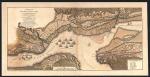
Source :
PLAN EXACT des ENVIRONS DE QUEBEC, et de la bataille du 13 septembre 1759 [Original en anglais]
Réf. :
A CORRECT PLAN of the ENVIRONS OF QUEBEC, and of the Battle fought on the 13th September, 1759: Together with a particular Detail of The French Lines and Batteries, and also of the Encampments, Batteries and attacks of the British Army, and the Investiture of that City under the Command of ICE ADMIRAL SAUNDERS, MAJOR GENERAL WOLFE, BRIGADIER GENERAL MONCTON, and BRIGADIE GENERAL TOWNSHEND.
Archives Nationales du Canada
NMC 21042 (H2), NMC 54105 (A) [1759?]
Auteur :
Thomas Jefferys
Géographe pour SA MAJESTÉ
Sujet :
Carte officielle de la bataille des Plaines d'Abraham produite par le géographe Thomas Jefferys à partir des plans détaillés fournis par les ingénieurs de l'Armée britannique. La carte indique l'emplacement des troupes, de l'artillerie et des navires britanniques et français de même que la position des postes de commandement.
