Source:
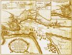
An authentic plan of the River St. Laurence from Sillery to the Fall of Montmorenci with the operations of the Siege of Québec...
Ref.:
Jefferys, Thomas, m. 1771
An authentic plan of the River St. Laurence from Sillery to the Fall of Montmorenci with the operations of the Siege of Québec... /
[London] : [Jefferys], [1759]
Bibliothèque nationale du Québec
Collection numérique
G 3452 Q4R1 1759 J4
Author:
Thomas Jefferys
Geographer to His MAJESTY
Subject:
Official map of the battle of the Plains of Abraham produced by geographer Thomas Jefferys for the British Crown, drawn from the original surveys taken by the Engineers of the Army. The map shows the location of French and British troops, artillery and ships, as well as the camps of the military leaders.

